|
| at: |
South Oconee National Forest |
Data from David Muse
 show on map
 animate
Trail users:


Elevation Profile
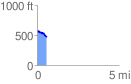
 0.593707 mi
 14.39 ft
 119.23 ft
 -104.84 ft
 3.80 %
GPX Downloads: Track Route
![]()
|
| at: |
South Oconee National Forest |
show on map
animate
0.593707 mi
14.39 ft
119.23 ft
-104.84 ft
3.80 %