|
| at: |
South Oconee National Forest |
Data from David Muse
 show on map
 animate
Trail users:


Elevation Profile
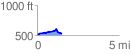
 1.534075 mi
 125.26 ft
 103.70 ft
 21.55 ft
 1.55 %
GPX Downloads: Track Route
![]()
|
| at: |
South Oconee National Forest |
show on map
animate
1.534075 mi
125.26 ft
103.70 ft
21.55 ft
1.55 %