|
| at: |
Lake Russell WMA |
Data from USFS GIS
 show on map
 animate
Trail users:


Elevation Profile
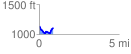
 0.876697 mi
 137.40 ft
 164.91 ft
 -27.50 ft
 3.56 %
GPX Downloads: Track Route
![]()
|
| at: |
Lake Russell WMA |
show on map
animate
0.876697 mi
137.40 ft
164.91 ft
-27.50 ft
3.56 %