|
| at: |
Swallow Creek WMA |
Data from David Muse
 show on map
 animate
Trail users:


Elevation Profile
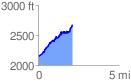
 2.126416 mi
 742.67 ft
 211.60 ft
 531.08 ft
 6.61 %
GPX Downloads: Track Route
![]()
|
| at: |
Swallow Creek WMA |
show on map
animate
2.126416 mi
742.67 ft
211.60 ft
531.08 ft
6.61 %