|
| at: |
South Fork |
Data from David Muse
 show on map
 animate
Trail users:


Elevation Profile
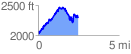
 2.483031 mi
 1011.57 ft
 819.78 ft
 191.79 ft
 7.72 %
GPX Downloads: Track Route
![]()
|
| at: |
South Fork |
show on map
animate
2.483031 mi
1011.57 ft
819.78 ft
191.79 ft
7.72 %