|
| at: |
North Oconee National Forest |
Data from David Muse
 show on map
 animate
Trail users:


Elevation Profile
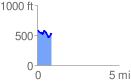
 0.886455 mi
 137.65 ft
 187.51 ft
 -49.87 ft
 4.01 %
GPX Downloads: Track Route
![]()
|
| at: |
North Oconee National Forest |
show on map
animate
0.886455 mi
137.65 ft
187.51 ft
-49.87 ft
4.01 %