|
| at: |
North Oconee National Forest |
Data from David Muse
 show on map
 animate
Trail users:


Elevation Profile
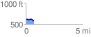
 0.702898 mi
 21.80 ft
 65.27 ft
 -43.47 ft
 1.76 %
GPX Downloads: Track Route
![]()
|
| at: |
North Oconee National Forest |
show on map
animate
0.702898 mi
21.80 ft
65.27 ft
-43.47 ft
1.76 %