|
| at: |
South Oconee National Forest |
Data from David Muse
 show on map
 animate
Trail users:


Elevation Profile
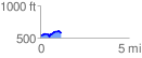
 1.179962 mi
 113.93 ft
 77.44 ft
 36.50 ft
 1.83 %
GPX Downloads: Track Route
![]()
|
| at: |
South Oconee National Forest |
show on map
animate
1.179962 mi
113.93 ft
77.44 ft
36.50 ft
1.83 %