|
| at: |
South Oconee National Forest |
Data from David Muse
 show on map
 animate
Trail users:


Elevation Profile
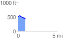
 0.949212 mi
 35.71 ft
 120.95 ft
 -85.24 ft
 2.41 %
GPX Downloads: Track Route
![]()
|
| at: |
South Oconee National Forest |
show on map
animate
0.949212 mi
35.71 ft
120.95 ft
-85.24 ft
2.41 %