|
| at: |
Iron Mountain/Sumac Creek |
Data from David Muse
 show on map
 animate
Trail users:


Elevation Profile
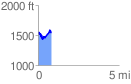
 0.808781 mi
 242.60 ft
 223.37 ft
 19.22 ft
 5.68 %
GPX Downloads: Track Route
![]()
|
| at: |
Iron Mountain/Sumac Creek |
show on map
animate
0.808781 mi
242.60 ft
223.37 ft
19.22 ft
5.68 %