|
| at: |
Iron Mountain/Sumac Creek |
Data from David Muse
 show on map
 animate
Trail users:


Elevation Profile
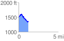
 1.231047 mi
 168.64 ft
 327.05 ft
 -158.41 ft
 5.03 %
GPX Downloads: Track Route
![]()
|
| at: |
Iron Mountain/Sumac Creek |
show on map
animate
1.231047 mi
168.64 ft
327.05 ft
-158.41 ft
5.03 %