|
| at: |
Gumlog Mountain/Brasstown Bald |
Data from David Muse
 show on map
 animate
Trail users:


Elevation Profile
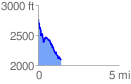
 1.409115 mi
 172.93 ft
 852.83 ft
 -679.90 ft
 11.46 %
GPX Downloads: Track Route
![]()
|
| at: |
Gumlog Mountain/Brasstown Bald |
show on map
animate
1.409115 mi
172.93 ft
852.83 ft
-679.90 ft
11.46 %