|
| at: |
Johns Mountain WMA |
Data from David Muse
 show on map
 animate
Trail users:


Elevation Profile
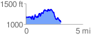
 3.108796 mi
 889.75 ft
 1016.95 ft
 -127.20 ft
 6.20 %
GPX Downloads: Track Route
![]()
|
| at: |
Johns Mountain WMA |
show on map
animate
3.108796 mi
889.75 ft
1016.95 ft
-127.20 ft
6.20 %