|
| at: |
Swallow Creek WMA |
Data from David Muse
 show on map
 animate
Trail users:


Elevation Profile
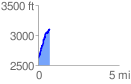
 0.718968 mi
 519.29 ft
 34.82 ft
 484.47 ft
 13.68 %
GPX Downloads: Track Route
![]()
|
| at: |
Swallow Creek WMA |
show on map
animate
0.718968 mi
519.29 ft
34.82 ft
484.47 ft
13.68 %