|
| at: |
Iron Mountain/Sumac Creek |
Data from David Muse
 show on map
 animate
Trail users:


Elevation Profile
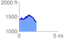
 2.228921 mi
 444.59 ft
 535.97 ft
 -91.38 ft
 4.55 %
GPX Downloads: Track Route
![]()
|
| at: |
Iron Mountain/Sumac Creek |
show on map
animate
2.228921 mi
444.59 ft
535.97 ft
-91.38 ft
4.55 %