| at: |
Cashes Valley |
Data from USFS GIS
 show on map
 animate
Trail users:

Elevation Profile
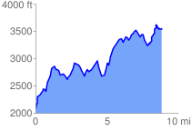
 8.855807 mi
 3404.30 ft
 1920.66 ft
 1483.64 ft
 7.28 %
Links:
Benton MacKaye in Google Earth/Maps
GPX Downloads: Track Route
![]()
| at: |
Cashes Valley |
show on map
animate
8.855807 mi
3404.30 ft
1920.66 ft
1483.64 ft
7.28 %