|
| at: |
Beasley Knob |
Data from David Muse
 show on map
 animate
Trail users:


Elevation Profile
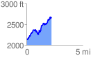
 2.277795 mi
 982.13 ft
 441.72 ft
 540.41 ft
 8.17 %
GPX Downloads: Track Route
![]()
|
| at: |
Beasley Knob |
show on map
animate
2.277795 mi
982.13 ft
441.72 ft
540.41 ft
8.17 %