|
| at: |
Iron Mountain/Sumac Creek |
Data from David Muse
 show on map
 animate
Trail users:


Elevation Profile
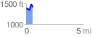
 0.572593 mi
 188.46 ft
 140.07 ft
 48.39 ft
 6.23 %
GPX Downloads: Track Route
![]()
|
| at: |
Iron Mountain/Sumac Creek |
show on map
animate
0.572593 mi
188.46 ft
140.07 ft
48.39 ft
6.23 %