|
| at: |
South Oconee National Forest |
Data from David Muse
 show on map
 animate
Trail users:


Elevation Profile
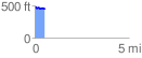
 0.533875 mi
 39.61 ft
 64.71 ft
 -25.10 ft
 2.30 %
GPX Downloads: Track Route
![]()
|
| at: |
South Oconee National Forest |
show on map
animate
0.533875 mi
39.61 ft
64.71 ft
-25.10 ft
2.30 %