|
| at: |
Coleman River Scenic Area |
Data from David Muse
 show on map
 animate
Trail users:


Elevation Profile
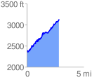
 2.853217 mi
 1171.17 ft
 440.85 ft
 730.32 ft
 7.77 %
GPX Downloads: Track Route
![]()
|
| at: |
Coleman River Scenic Area |
show on map
animate
2.853217 mi
1171.17 ft
440.85 ft
730.32 ft
7.77 %