|
| at: |
Johns Mountain WMA |
Data from David Muse
 show on map
 animate
Trail users:


Elevation Profile
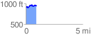
 0.921508 mi
 138.21 ft
 87.56 ft
 50.65 ft
 2.84 %
GPX Downloads: Track Route
![]()
|
| at: |
Johns Mountain WMA |
show on map
animate
0.921508 mi
138.21 ft
87.56 ft
50.65 ft
2.84 %