|
| at: |
Coleman River Scenic Area |
Data from David Muse
 show on map
 animate
Trail users:


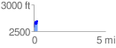
Elevation Profile
 0.273247 mi
 193.81 ft
 84.64 ft
 109.17 ft
 13.43 %
GPX Downloads: Track Route
![]()
|
| at: |
Coleman River Scenic Area |
show on map
animate
0.273247 mi
193.81 ft
84.64 ft
109.17 ft
13.43 %