|
| at: |
Coleman River Scenic Area |
Data from David Muse
 show on map
 animate
Trail users:


Elevation Profile
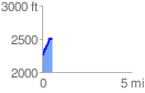
 0.581852 mi
 286.81 ft
 34.11 ft
 252.70 ft
 9.34 %
GPX Downloads: Track Route
![]()
|
| at: |
Coleman River Scenic Area |
show on map
animate
0.581852 mi
286.81 ft
34.11 ft
252.70 ft
9.34 %