|
| at: |
South Oconee National Forest |
Data from David Muse
 show on map
 animate
Trail users:


Elevation Profile
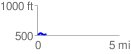
 0.572157 mi
 33.40 ft
 27.15 ft
 6.25 ft
 1.11 %
GPX Downloads: Track Route
![]()
|
| at: |
South Oconee National Forest |
show on map
animate
0.572157 mi
33.40 ft
27.15 ft
6.25 ft
1.11 %