| at: |
Clark Creek Natural Area |
Data from David Muse
 show on map
 animate
Trail users:

Elevation Profile
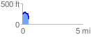
 0.552489 mi
 68.18 ft
 208.18 ft
 -140.01 ft
 7.14 %
GPX Downloads: Track Route
![]()
| at: |
Clark Creek Natural Area |
show on map
animate
0.552489 mi
68.18 ft
208.18 ft
-140.01 ft
7.14 %