|
| at: |
North Oconee National Forest |
Data from David Muse
 show on map
 animate
Trail users:


Elevation Profile
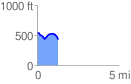
 1.298956 mi
 94.72 ft
 209.90 ft
 -115.18 ft
 3.06 %
GPX Downloads: Track Route
![]()
|
| at: |
North Oconee National Forest |
show on map
animate
1.298956 mi
94.72 ft
209.90 ft
-115.18 ft
3.06 %