|
| at: |
South Oconee National Forest |
Data from David Muse
 show on map
 animate
Trail users:


Elevation Profile
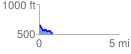
 0.835896 mi
 42.58 ft
 165.51 ft
 -122.93 ft
 3.75 %
GPX Downloads: Track Route
![]()
|
| at: |
South Oconee National Forest |
show on map
animate
0.835896 mi
42.58 ft
165.51 ft
-122.93 ft
3.75 %