|
| at: |
South Oconee National Forest |
Data from David Muse
 show on map
 animate
Trail users:


Elevation Profile
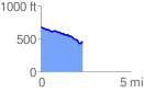
 2.323211 mi
 51.98 ft
 261.65 ft
 -209.67 ft
 2.13 %
GPX Downloads: Track Route
![]()
|
| at: |
South Oconee National Forest |
show on map
animate
2.323211 mi
51.98 ft
261.65 ft
-209.67 ft
2.13 %