|
| at: |
North Oconee National Forest |
Data from David Muse
 show on map
 animate
Trail users:


Elevation Profile
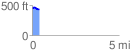
 0.446847 mi
 18.45 ft
 33.94 ft
 -15.49 ft
 1.44 %
GPX Downloads: Track Route
![]()
|
| at: |
North Oconee National Forest |
show on map
animate
0.446847 mi
18.45 ft
33.94 ft
-15.49 ft
1.44 %