|
| at: |
North Oconee National Forest |
Data from David Muse
 show on map
 animate
Trail users:


Elevation Profile
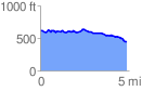
 4.886515 mi
 251.11 ft
 428.41 ft
 -177.30 ft
 1.66 %
GPX Downloads: Track Route
![]()
|
| at: |
North Oconee National Forest |
show on map
animate
4.886515 mi
251.11 ft
428.41 ft
-177.30 ft
1.66 %