|
| at: |
South Oconee National Forest |
Data from David Muse
 show on map
 animate
Trail users:


Elevation Profile
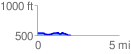
 2.088605 mi
 61.03 ft
 103.73 ft
 -42.70 ft
 0.94 %
GPX Downloads: Track Route
![]()
|
| at: |
South Oconee National Forest |
show on map
animate
2.088605 mi
61.03 ft
103.73 ft
-42.70 ft
0.94 %