|
| at: |
South Oconee National Forest |
Data from David Muse
 show on map
 animate
Trail users:


Elevation Profile
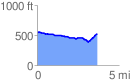
 3.658312 mi
 172.46 ft
 197.41 ft
 -24.95 ft
 1.02 %
GPX Downloads: Track Route
![]()
|
| at: |
South Oconee National Forest |
show on map
animate
3.658312 mi
172.46 ft
197.41 ft
-24.95 ft
1.02 %