|
| at: |
South Oconee National Forest |
Data from David Muse
 show on map
 animate
Trail users:


Elevation Profile
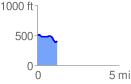
 1.207847 mi
 49.64 ft
 158.06 ft
 -108.42 ft
 2.48 %
GPX Downloads: Track Route
![]()
|
| at: |
South Oconee National Forest |
show on map
animate
1.207847 mi
49.64 ft
158.06 ft
-108.42 ft
2.48 %