|
| at: |
Chestatee WMA |
Data from David Muse
 show on map
 animate
Trail users:


Elevation Profile
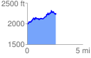
 2.595869 mi
 730.62 ft
 478.89 ft
 251.73 ft
 5.33 %
GPX Downloads: Track Route
![]()
|
| at: |
Chestatee WMA |
show on map
animate
2.595869 mi
730.62 ft
478.89 ft
251.73 ft
5.33 %