|
| at: |
Beasley Knob |
Data from David Muse
 show on map
 animate
USFS GIS data also shows this as Access Trail 93A. Part of it is also shown as being part of the Nicholson Gap Trail. It may or may not still be a proper road and may not be open to bikes or horses.
Trail users:


Elevation Profile
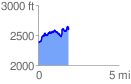
 1.898172 mi
 573.21 ft
 354.57 ft
 218.65 ft
 5.72 %
GPX Downloads: Track Route