|
| at: |
Lake Russell WMA |
Data from USFS GIS
 show on map
 animate
Trail users:


Elevation Profile
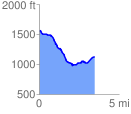
 3.477448 mi
 253.45 ft
 664.58 ft
 -411.14 ft
 3.62 %
GPX Downloads: Track Route
![]()
|
| at: |
Lake Russell WMA |
show on map
animate
3.477448 mi
253.45 ft
664.58 ft
-411.14 ft
3.62 %