| at: |
Cheaha State Park |
Data from David Muse
 show on map
 animate
Trail users:


Elevation Profile
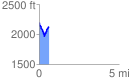
 0.608734 mi
 158.30 ft
 214.35 ft
 -56.06 ft
 6.67 %
GPX Downloads: Track Route
Trailheads:
 Cheaha State Park
![]()
| at: |
Cheaha State Park |
show on map
animate
0.608734 mi
158.30 ft
214.35 ft
-56.06 ft
6.67 %
Cheaha State Park