|
| at: |
Johns Mountain WMA |
Data from David Muse
 show on map
 animate
Trail users:


Elevation Profile
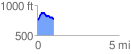
 1.015555 mi
 164.96 ft
 151.59 ft
 13.37 ft
 3.08 %
GPX Downloads: Track Route
![]()
|
| at: |
Johns Mountain WMA |
show on map
animate
1.015555 mi
164.96 ft
151.59 ft
13.37 ft
3.08 %