|
| at: |
North Oconee National Forest |
Data from David Muse
 show on map
 animate
Trail users:


Elevation Profile
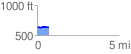
 0.748965 mi
 33.57 ft
 22.06 ft
 11.51 ft
 0.85 %
GPX Downloads: Track Route
![]()
|
| at: |
North Oconee National Forest |
show on map
animate
0.748965 mi
33.57 ft
22.06 ft
11.51 ft
0.85 %