|
| at: |
South Oconee National Forest |
Data from David Muse
 show on map
 animate
Trail users:


Elevation Profile
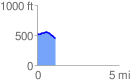
 1.124539 mi
 48.68 ft
 129.53 ft
 -80.84 ft
 2.18 %
GPX Downloads: Track Route
![]()
|
| at: |
South Oconee National Forest |
show on map
animate
1.124539 mi
48.68 ft
129.53 ft
-80.84 ft
2.18 %