|
| at: |
South Oconee National Forest |
Data from David Muse
 show on map
 animate
Trail users:


Elevation Profile
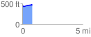
 0.846267 mi
 62.86 ft
 37.06 ft
 25.80 ft
 1.41 %
GPX Downloads: Track Route
![]()
|
| at: |
South Oconee National Forest |
show on map
animate
0.846267 mi
62.86 ft
37.06 ft
25.80 ft
1.41 %