|
| at: |
Wolf Creek Area |
Data from David Muse
 show on map
 animate
Trail users:


Elevation Profile
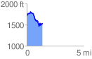
 1.395497 mi
 223.51 ft
 413.69 ft
 -190.18 ft
 5.61 %
GPX Downloads: Track Route
![]()
|
| at: |
Wolf Creek Area |
show on map
animate
1.395497 mi
223.51 ft
413.69 ft
-190.18 ft
5.61 %