|
| at: |
Lake Russell WMA |
Data from Positive Flow
 show on map
 animate
USFS GIS data shows that part of this road is part of the Ladyslipper Trail.
Trail users:


Elevation Profile
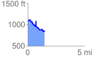
 1.486708 mi
 233.18 ft
 434.61 ft
 -201.43 ft
 5.54 %
GPX Downloads: Track Route