| at: |
North Oconee National Forest |
Data from David Muse
 show on map
 animate
Trail users:


Elevation Profile
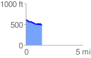
 1.441437 mi
 61.30 ft
 184.64 ft
 -123.34 ft
 2.43 %
GPX Downloads: Track Route
![]()
| at: |
North Oconee National Forest |
show on map
animate
1.441437 mi
61.30 ft
184.64 ft
-123.34 ft
2.43 %