| at: |
Camp Thunder |
Data from Dean Thornton
 show on map
 animate
Trail users:


Elevation Profile
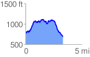
 3.352028 mi
 661.52 ft
 750.67 ft
 -89.15 ft
 4.24 %
GPX Downloads: Track Route
![]()
| at: |
Camp Thunder |
show on map
animate
3.352028 mi
661.52 ft
750.67 ft
-89.15 ft
4.24 %