| at: |
Camp Thunder |
Data from Dean Thornton
 show on map
 animate
Trail users:


Elevation Profile
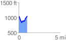
 1.036765 mi
 246.53 ft
 253.09 ft
 -6.56 ft
 4.62 %
GPX Downloads: Track Route
![]()
| at: |
Camp Thunder |
show on map
animate
1.036765 mi
246.53 ft
253.09 ft
-6.56 ft
4.62 %