| at: |
Camp Thunder |
Data from Dean Thornton
 show on map
 animate
Trail users:


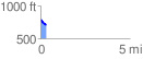
Elevation Profile
 0.306566 mi
 0.00 ft
 89.75 ft
 -89.75 ft
 5.54 %
GPX Downloads: Track Route
![]()
| at: |
Camp Thunder |
show on map
animate
0.306566 mi
0.00 ft
89.75 ft
-89.75 ft
5.54 %