| at: |
Camp Thunder |
Data from Dean Thornton
 show on map
 animate
Trail users:


Elevation Profile
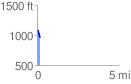
 0.200596 mi
 0.00 ft
 145.98 ft
 -145.98 ft
 13.78 %
GPX Downloads: Track Route
![]()
| at: |
Camp Thunder |
show on map
animate
0.200596 mi
0.00 ft
145.98 ft
-145.98 ft
13.78 %