| at: |
Camp Thunder |
Data from Dean Thornton
 show on map
 animate
Trail users:


Elevation Profile
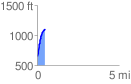
 0.471691 mi
 446.85 ft
 4.96 ft
 441.88 ft
 17.94 %
GPX Downloads: Track Route
![]()
| at: |
Camp Thunder |
show on map
animate
0.471691 mi
446.85 ft
4.96 ft
441.88 ft
17.94 %