| at: |
Rich Mountain Trans North Georgia |
Data from David Muse
 show on map
 animate
Trail users:


Elevation Profile
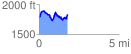
 1.788985 mi
 423.95 ft
 360.47 ft
 63.48 ft
 4.49 %
GPX Downloads: Track Route
![]()
| at: |
Rich Mountain Trans North Georgia |
show on map
animate
1.788985 mi
423.95 ft
360.47 ft
63.48 ft
4.49 %